Don't get me wrong, I really do enjoy writing about all the fun experiences I'm having outside of work. But since this is not exactly a tourist visit to Africa, I do feel compelled to write a bit about the work side of things from time to time. As I've said to folks in various emails, it has taken time for me to understand the workings of Council and the meaning of planning in an African context. It was difficult to know where to jump in without first becoming familiar with the landscape and layout of Mazabuka, and to make a few contacts in town. Now that the “getting to know you” phase is over, I feel we're well set to make some progress on the IDP.
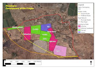
There are more than a few urban planning issues to write about, but I will focus on the state of development at the fringes of the existing built up area, as well as the proposed truck by-pass road. To help illustrate my notes, I've included a map of Mazabuka, which I produced in a handy little GIS program called Quantum GIS. It took some getting used to, but it basically does all the same things that ArcGIS can do for about $3,000 less. Yes, it's a freeware program.
As I've reported before, numerous trucks pass through the urban area of Mazabuka, sometimes with disastrous results as they try to negotiate the turn near the Shoprite supermarket. For quite some time, people have talked about building a by-pass road to divert a major share of the trucks from the centre of town, but nothing concrete has been done to make it a reality. As a result of my urging (and ultimate legwork), we did manage to organize a trip to Lusaka this week to meet with the national Road Development Agency. The meeting had a positive outcome though obviously a lot of work remains to be done before any tarmac is laid. If the Council can arrange to survey the necessary right of way by mid-late 2011, the RDA agreed that construction of the road could be included in their 2012 budget. Good news if the conditions can be met.
In order to understand where the road should pass, I visited the area with the Council surveyor/draughtsman last week. We made some interesting findings. I had heard of some informal developments occurring in the area but the extent of the area was really surprising. Despite the large extent, the development occurring there is not particularly intensive or dense. I am told that the farmers who own the land have been busily carving out plots for people to build homes. Nothing new, I know.
What is a bit alarming is that the Council seems to have little control over the subdivision and allocation of these lands. Naturally, there is also a legitimate demand by the new settlers for the electric and water companies to extend some degree of service to these unplanned areas. Unfortunately, I sense a somewhat blasé attitude toward the settlers, which goes something along the lines of: “They're illegal settlements. We can move them.” Technically and legally, this may be true, but in the end who will step in to play the bad guy when people have earnestly cobbled together some money to acquire some land and build their homes using their own labour? It's not a job I would savour.
On the map, which you can click to produce a larger version, I've attempted to illustrate the extent of the new development areas, as well as the proposed route for the by-pass road. In total, the coloured areas encompass nearly 400 hectares (995 acres) and all at very low development densities. The yellow line was the original concept route for the by-pass, which we quickly discovered would be difficult to build. Notwithstanding the rapidly advancing settlements (including a planned settlement called Kabobola Extension), there is also an elevated rocky outcrop in the centre of the area, which would require lots of expensive blasting. So we drew another potential route on the map in orange. The total length of the “preferred route” is just over 7 kilometres.
 |
| Planned and informal settlements at the fringe of Mazabuka. (click on the map for an enlargement) |
In conclusion, I just want to say that sprawl isn't confined to North American or European cities – it happens everywhere. For a Council that already struggles to build and maintain basic infrastructure, these new development areas could prove to be extremely expensive in the long run. I am now left scratching my head about how I might get the message across to the decision makers...
So...as I'm reading this post, I'm thinking "man, I wish Andrew was still in Ottawa 'cause he could totally come in and talk to my grade 3s about urban and rural communities. Plus, I totally miss him."
ReplyDeleteLove you,
Jen :O D
That sounds like fun! I'd love to talk to kids about planning; book me for when I return. :-)
ReplyDeleteI miss you too!
Andrew xo